
Wikipedia has thousands of articles about rivers. What are the most important facts about a river? Some can be described with numbers, such as its length, width, or average flow.
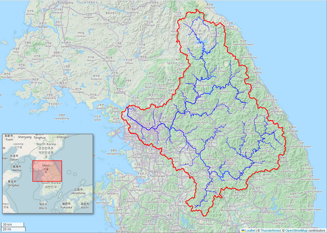
I think that every Wikipedia article about a river should include a watershed map. A map can tell you so much, including the landscape features that affect a river’s flow and water quality.
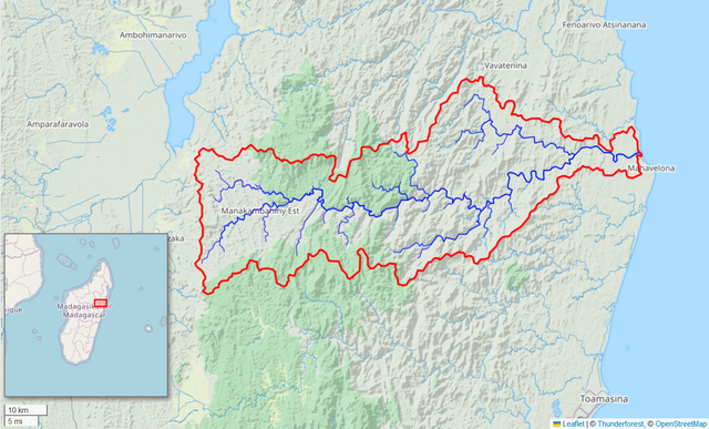
You can make a high-quality map using the free Global Watersheds web app. It is fast and easy. The best part is that you can include a link to a live, interactive map. Below is an example, followed by step-by-step instructions.
Advantages:
- Fast, easy
- No need for special software like GIS, Illustrator, etc.
- Choice of different basemaps makes styling your map simple
- Can include a permalink to an interactive map
Disadvantages:
- Maps are low resolution, not suitable for print use
- Maps are in Web Mercator projection; areas and shapes are distorted, especially at northern latitudes
- The results of automatic watershed delineation are not always accurate, and need to be verified
Tutorial
Here are step-by-step instructions on how to make a watershed map for Wikipedia using the Global Watersheds web app.
- First, find your watershed. Use the “Delineate” function in the Global Watersheds app. If you’re in the continental US, consider setting Data Source to “USGS” for better accuracy.
- Pan and zoom until the map looks how you like.
- Adjust the appearance of your map. You can experiment with different base maps to see which looks best, and which shows the features you are interested in. Try adjusting the opacity of the basemap for better appearance.
- Hide map controls: Under options, click “Hide Map Controls” to get a cleaner looking map. This hides the map control widgets, but keeps the scale bar and credits text at the bottom. Makes screenshots a little bit nicer.
- Show an inset locator map: This is helpful for showing where in the world your map is located. The locator map can be zoomed with the mouse and scroll wheel. Move by clicking near the top and dragging. Resize using either the right or bottom edge.
- Take a screenshot, crop out the unnecessary elements, and save the image file. Wikipedia prefers PNG, but JPG or other formats are accepted too.
- Create a permalink. Link to an interactive watershed map using the share your watershed feature. You can include the link in the image caption.
One disadvantage of using the app is that maps are in the Web Mercator projection, which can distort shapes and areas, especially at higher latitudes. Another disadvantage is that rivers are not clearly labeled, although some base map layers include river names. In the US, the “USGS Topographic Maps” layer include labels for many hydrographic features like rivers and lakes.
If you have followed these steps, you can now add your map to Wikipedia, or your blog, or wherever you’d like a static watershed map.
- In Wikipedia, choose “Edit” near the top right of the article. Many articles about rivers have an “infobox.” If so, you put the map there. If there isn’t an infobox, consider creating one.
- Follow the instructions to upload a new image. You will have to certify that you are the creator, and assign a Creative Commons license to the image, which means others can freely share and reuse the image.
- Give your map a caption. Here is a suggested template:
Kaministiquia River watershed ([https://mghydro.com/watersheds/shared/B6C658.html Interactive map]) - Tag your image with categories. Here were the tags suggested by an experienced editor:
- Maps of drainage basins from Global Watersheds
- NAME OF RIVER
- OpenStreetMap maps of LOCATION
If you know other languages, consider adding the map to the article in those languages too!
I’ve made several dozen maps (gallery on Wikimedia). It generally takes me about 5 or 10 minutes. All in all, it’s a fun way to explore and contribute to global watershed consciousness!
If you have any questions or comments, please be in touch.